A historical weather report shows what hit a property and when. Here is where weather data for a claim comes from, what a carrier-ready report has to include, and how to download a verified hail, wind, and tornado report for any address in Drodat.
When a carrier questions a hail or wind claim, the first thing it questions is the weather. Did a storm actually hit this property? On what day? How big was the hail, and how strong was the wind?
A historical weather report answers those questions with data tied to the property’s address and date of loss. This guide covers where that data comes from, what a report needs to include to hold up, and how to pull a verified report for any address in a couple of minutes.
What is a historical weather report?
A historical weather report is a record of the weather events that affected a specific location on specific dates. For a property claim, the events that matter are the ones that cause damage: hail, damaging wind, and tornadoes. A useful report ties each event to the property’s address, gives its date, measures it (hail size, wind speed and direction), and shows how far it was from the property.
Public adjusters, roofers, restoration contractors, and attorneys use these reports to establish the date of loss, show that a storm was strong enough to cause the damage, and answer a carrier that says the damage is old wear and tear.
Where does weather data for a claim come from?
Most weather evidence starts with public data from NOAA and the National Weather Service:
- Storm reports. Local Storm Reports from National Weather Service offices and the Storm Prediction Center’s daily reports log hail, wind, and tornado reports by location. They are fast, but they depend on someone reporting what they saw.
- The NOAA Storm Events Database. The official historical record of significant storms, maintained by NOAA’s National Centers for Environmental Information. It is thorough, but entries are summarized by county or zone and are often published months after the storm.
- Radar estimates. NOAA’s Multi-Radar Multi-Sensor (MRMS) system estimates hail size from radar across the country, including places where nobody was there to report it.
Each source answers part of the question. None of them, on its own, tells you what happened at one specific house on one specific day. That is the gap a property-level report fills.
What a carrier-ready weather report needs
Before you send a weather report with a claim, make sure it includes:
- The property’s address, not just the county or nearest city
- The date of each event, so it can be matched to the date of loss
- The measurement: hail size for hail events, wind speed and direction for wind events
- The distance from the event to the property
- The full picture, not only one storm, so you can show which event is the most likely cause
- A way to verify it, so the carrier can confirm the report has not been altered
How to get a historical weather report in Drodat
Every property you add to Drodat already has its weather history. There is nothing to order.
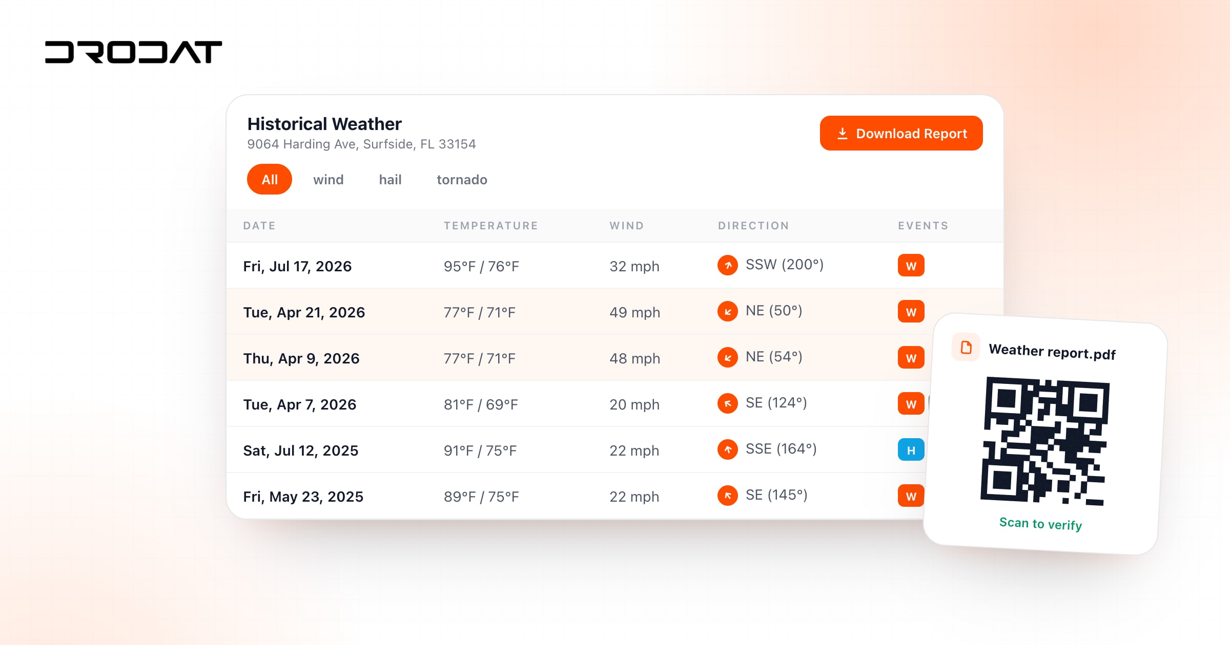
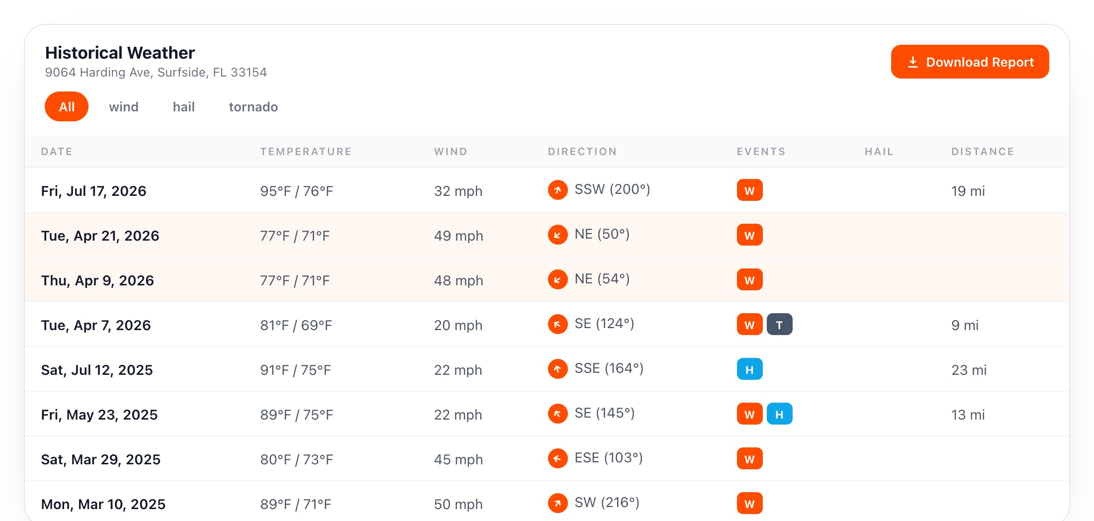
- Open the property. The Historical Weather tab lists every hail, wind, and tornado event recorded at the property’s location over about the last four years.
- Filter the events. Show all events, or only wind, hail, or tornado.
- Find the match. Each event shows its date, the high and low temperature, the wind speed and direction, the hail size, and the distance from the property. Line up the event with the damage you found and the date of loss your client reported.
- Download the report. Export one event or the full history as a PDF. Every PDF carries a QR code that opens the original report on Drodat’s servers, so anyone can confirm it has not been changed.
Drodat does not rely on a single weather station. It interpolates data from multiple surrounding sources to build a hyperlocal record for the property’s exact location, and it checks each property every day for new events, with alerts sent to the people you choose.
A real example
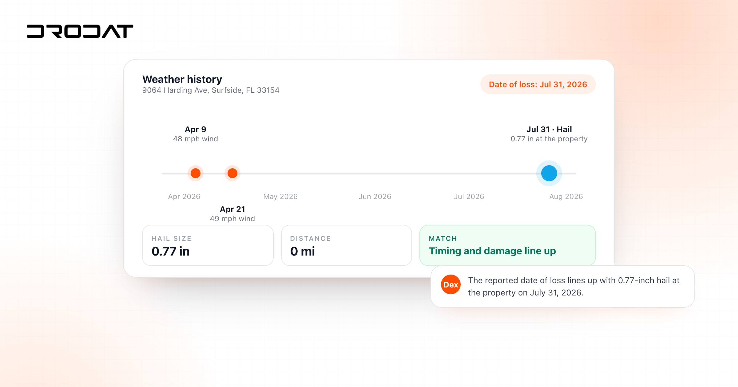
On Drodat’s demo property in Surfside, Florida, the weather history shows 49 mph wind gusts from the northeast on April 21, 2026, and 48 mph gusts from the northeast twelve days earlier, on April 9. It also shows a 50 mph gust from the southwest on March 10, 2025. If a client reports wind damage on the northeast side of the roof this spring, the April events line up with both the timing and the direction, and the full history shows the earlier storms the carrier might point to instead.
Single-event report or full history?
Use a single-event report when the date of loss is clear and you want one clean page for the carrier. Use the full history when the date is uncertain, when the carrier argues the damage came from an earlier storm, or when you are building a file for appraisal or litigation and want the complete record.
Common mistakes to avoid
- Using city-level weather. A storm that hit the north side of town may have missed the property entirely. Use address-level data.
- Picking the biggest storm instead of the right one. The event has to match the damage and the reported date of loss, not just be the most dramatic.
- Ignoring direction. For wind claims, the wind direction should make sense with the side of the house that was damaged.
- Sending an unverifiable screenshot. A report the carrier can verify is harder to dismiss.
Put the weather to work
A weather report is strongest when it sits next to the rest of the evidence. In Drodat, Dex checks the date of loss against the property’s weather history for you, historical aerial imagery shows the roof before the storm, and Storm Explorer shows every 1-inch hail storm in a state, mapped, with the addresses inside it. For the full method, read how to prove the date of loss with weather data.
Try Drodat
Get a verified weather report for any address
Add a property and its hail, wind, and tornado history is already there, ready to download as a QR-verified PDF.
Start your free trial
Frequently asked questions
How do I get a weather report for an insurance claim?
Look up the storm history for the property’s exact address, find the event that matches the damage and the date of loss, and download a report that shows the date, the hail size or wind speed, and the distance from the property. In Drodat, open the property’s Historical Weather tab and download one event or the full history as a QR-verified PDF.
What should a weather report for a claim include?
The property’s address, the date of each event, the hail size or wind speed and direction, the distance from the property, and a way to verify that the report has not been altered.
How far back does Drodat’s weather history go?
Drodat shows about the last four years of hail, wind, and tornado events for each property, and it checks the property every day for new events.
Is Drodat’s weather data from one weather station?
No. Drodat interpolates data from multiple surrounding sources to build a hyperlocal record for the property’s exact location, which is more precise than the nearest single station.
How does the QR code on a Drodat weather report work?
Every downloaded PDF includes a unique QR code. Scanning it opens the original report stored on Drodat’s servers, so anyone can confirm the report has not been altered.
Can I download a single storm instead of the full history?
Yes. You can download a report for one event, or the complete history for the property in one PDF.
About the Author

Jake Cox
Jake Cox is a co-founder and the CMO of Drodat, the all-in-one claims management and CRM platform for public adjusters and property professionals. Based in Miami, he writes about lead generation, claim workflow, fire and storm prospecting, and the technology shaping the modern public adjusting firm. Drodat powers properties, intakes, contracts, e-signature, projects, financials, NOAA radar storm data, and real-time fire dispatch alerts for adjusters across the United States.